Volcanic SO2 Emission Inventory
Introduction
Injections of trace gases and ash by volcanic eruptions pose significant influences on the Earth's environment. Air pollutants such as sulfur dioxide (SO2), released by volcanic eruptions, can lead to a severe public health hazard and increase excess mortality. In addition, volcanic ash and gases can directly interrupt air flights passing through the volcanic plume and cause long-term damage to airplanes through physical and chemical corrosion, such as sulfidation due to SO2.
Furthermore, volcanic injections can influence the Earth's climate system through changes of radiative forcing. Explosive volcanic eruptions can inject a significant amount of SO2 into the stratosphere, and oxidation of the SO2 forms stratospheric sulfate aerosol particles. Due to the limited potential of dry and wet deposition in the stratosphere, and due to the small sedimentation velocities, the sulfate aerosol particles have long lifetimes on timescales from months to years. In summary, as a precursor of stratospheric sulfate aerosol, and being a good proxy for other volcanic injections such as volcanic ash, monitoring and modeling of the injections and dispersion of volcanic SO2 can help to better understand the impacts of volcanic eruptions.
Although in situ observations are available for several well-studied volcanoes, remote-sensing measurements from satellite instruments are more suited to provide long-term records and retrievals on a global scale. At present, there are several satellite instruments that can provide SO2 retrievals. Among them, the Atmospheric Infrared Sounder (AIRS) aboard the National Aeronautics and Space Administration's (NASA) Aqua satellite provides retrievals of SO2 in the upper troposphere–lower stratosphere (UTLS) region. AIRS observations have been available since 2002 and have near-global coverage during both day- and nighttime.
Beside the satellite retrievals, model simulations can help to characterize volcanic eruptions and provide forecasts of volcanic plume dispersion. In particular, Lagrangian particle dispersion models (LPDMs), which calculate air parcel trajectories following the fluid flow, are well suited for simulating complex transport processes. A new LPDM, the Massive-Parallel Trajectory Calculations (MPTRAC) model, was developed at the Jülich Supercomputing Centre to take advantage of computing resources on state-of-the-art supercomputers. The MPTRAC model has been successfully used to reconstruct volcanic SO2 injections and simulate the long-range transport of volcanic SO2. This data repository provides access to SO2 emission estimates derived from AIRS satellite products and Lagrangian transport simulations using the MPTRAC model.
Data access
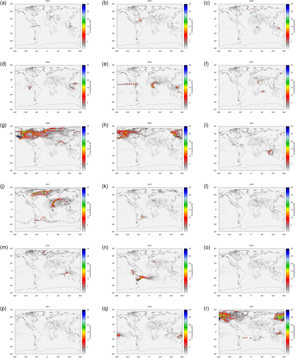
The browse images and emission data sets for more than fifty individual volcanic eruptions covered by this data repository can be accessed via an event list.
The volcanic emission data sets provided on this web site have been created using AIRS/Aqua L1B Infrared (IR) geolocated and calibrated radiances V005 distributed by the NASA Goddard Earth Sciences Data and Information Services Center (GES DISC). Please see the GES DISC website for further information on the AIRS/Aqua operational data products.
The sulfur dioxide emissions have been estimates using a backward trajectory method using the Lagrangian transport model MPTRAC. The transport simulations are mostly driven by ECMWF's ERA-Interim reanalysis meteorological data.
Note that this data repository provides access to non-operational research data products, which are dedicated to the research on volcanic emissions. The methods and data provided here are subject to further research and may be updated in the future to provide further improvements.
Legal notes
The data sets and browse images provided on this site are licensed under a Creative Commons Attribution 4.0 International License. You are free to share the material in any medium or format and adapt it for any purpose, even commercially. You must give appropriate credit, provide a link to the license, and indicate if changes were made. You may do so in any reasonable manner, but not in any way that suggests the licensor endorses you or your use. You may not apply legal terms or technological measures that legally restrict others from doing anything the license permits. The licensor cannot revoke these freedoms as long as you follow the license terms. The data are distributed in the hope that it will be useful, but without any warranty. Please follow the link to see the terms and conditions of the license:
References
This data repository can be cited via the following doi:
- Hoffmann, L., Cai, Z., Griessbach, S., Wu, X., and Zou, L., Volcanic SO2 Emission Inventory, Jülich DATA, V1, https://doi.org/10.26165/JUELICH-DATA/Q3FRHR, 2022.
The backward trajectory method to estimate volcanic emissions from AIRS/Aqua satellite data is described in the following publications:
- Cai, Z., Griessbach, S., and Hoffmann, L.: Improved estimation of volcanic SO2 injections from satellite retrievals and Lagrangian transport simulations: the 2019 Raikoke eruption, Atmos. Chem. Phys., 22, 6787–6809, https://doi.org/10.5194/acp-22-6787-2022, 2022.
- Wu, X., Griessbach, S., and Hoffmann, L.: Long-range transport of volcanic aerosol from the 2010 Merapi tropical eruption to Antarctica, Atmos. Chem. Phys., 18, 15859-15877, https://doi.org/10.5194/acp-18-15859-2018, 2018.
- Wu, X., Griessbach, S., and Hoffmann, L.: Equatorward dispersion of a high-latitude volcanic plume and its relation to the Asian summer monsoon: a case study of the Sarychev eruption in 2009, Atmos. Chem. Phys., 17, 13439-13455, https://doi.org/10.5194/acp-17-13439-2017, 2017.
- Hoffmann, L., T. Rößler, S. Griessbach, Y. Heng, and O. Stein, Lagrangian transport simulations of volcanic sulfur dioxide emissions: Impact of meteorological data products, J. Geophys. Res. Atmos., 121, 4651-4673, https://doi.org/10.1002/2015JD023749, 2016.
Acknowledgement
This work was supported by the Deutsche Forschungsgemeinschaft (DFG; grant no. HO5102/1-1).
Contact
We encourage any user interested in the data set to contact us for discussions on how you like to use the data. This might help to reduce the risk of mistaken applications and helps us to track the distribution and areas of applications of the data set.
Please do not hesitate to contact us if you have any further questions:
Dr. Lars Hoffmann
Forschungszentrum Jülich
Jülich Supercomputing Centre
52425 Jülich
Germany
e-mail: l.hoffmann@fz-juelich.de
![]()
